 TEXTILES.ORG

By Brian Maggi, Christopher D. P. Baxter, Aaron Bradshaw, Annette Grilli and Naser Al Naser
The devastating effects of recent hurricanes and nor’easters highlight the need to improve the resilience of coastal communities. There is a trend toward implementing “soft” engineering solutions such as dunes reinforced with geotextile sand containers (GSCs) or coastal bluffs stabilized with geotextile tubes to improve resiliency rather than traditional hardened structures like stone revetments. These have the potential to protect communities from some storm events (e.g., 25- or 50-year storms) while at the same time providing flexibility in design considering the uncertainty regarding rates of sea level rise and storm frequency. However, there are currently no accepted design standards for these geosystems, and general permit requirements vary state to state. While numerous lab experiments and numerical models have been developed to predict the hydraulic stability of coastal revetments made of GSCs and geotextile tubes, there has been limited in situ validation of GSC systems, especially when they are used to reinforce a natural system (Dassanayake and Oumeraci 2012).
The construction of a GSC-reinforced dune in Montauk, N.Y., in 2016 and a coastal bluff stabilized with geotextile tubes in Nantucket, Mass., in 2014 present excellent opportunities to assess the resilience, stability and impact of storms on these systems along with the maintenance requirements necessary to ensure longevity of the geotextiles and minimize the container impacts on adjacent natural environments. The Montauk monitoring program being conducted by the authors includes the use of interferometric sonar for nearshore bathymetry, real-time kinematic (RTK) differential GPS, ship-mounted LIDAR, and unmanned aerial vehicles (UAVs) with structure from motion (SfM) photogrammetry to develop cross-shore profiles and digital elevation models (DEMs) before and after storm events for the site. The Nantucket monitoring program is run by the Siasconset Beach Preservation Fund (SBPF) and project updates are regularly posted on SBPF’s website, www.sconsetbeach.org. Observations from the Montauk site are being used to calibrate erosion modeling of a reinforced dune/beach cross section using the wave propagation and sediment transport model XBeach and to validate the performance and stability of the GSCs. The Nantucket site provides additional background when assessing the level of monitoring and maintenance required for a reinforced natural system in a state where coastal protection systems are heavily regulated.
Background
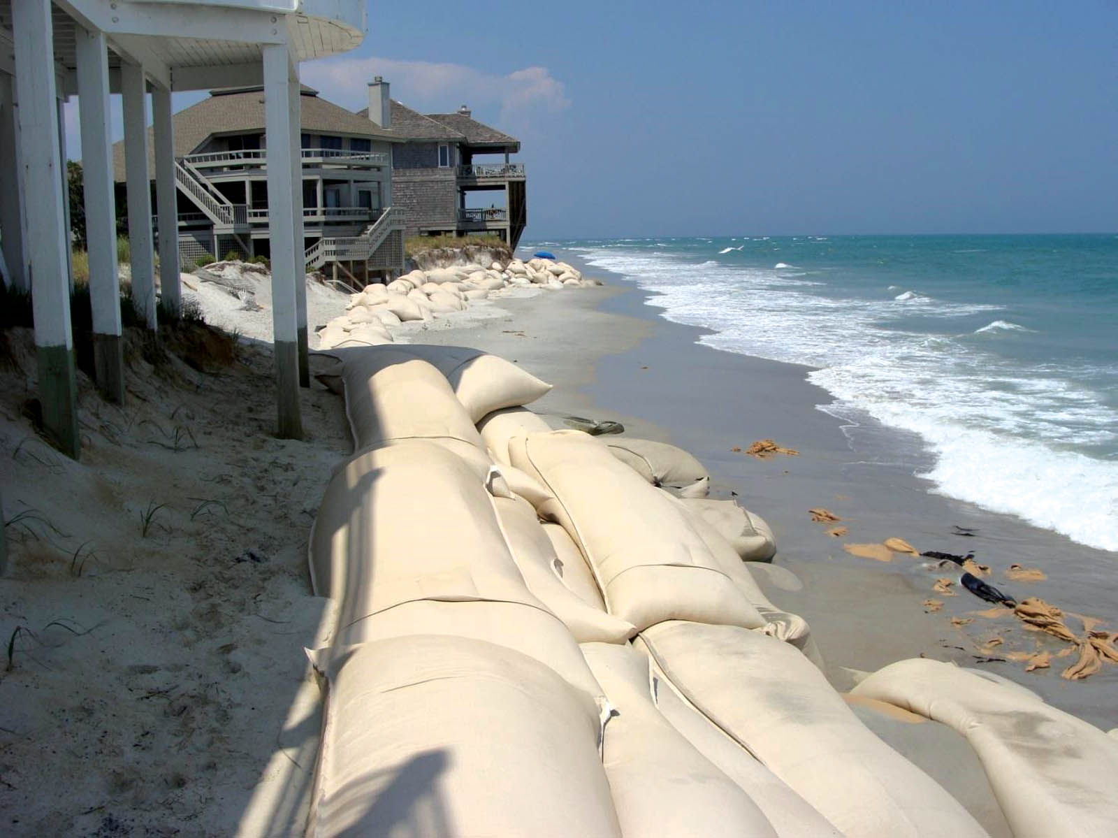
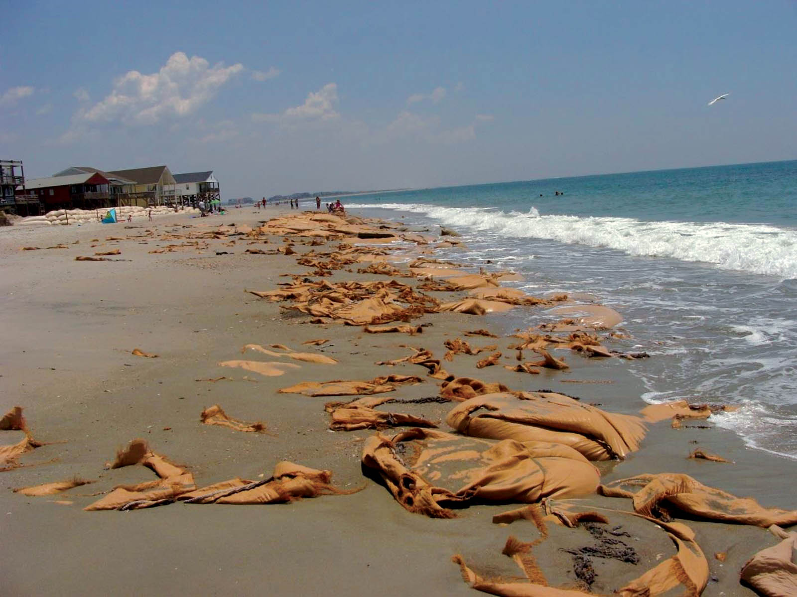
In many locations throughout the world, GSCs and geotextile tubes have proven to be effective stabilization solutions for temporary reinforcement and protection of vulnerable sections of coastlines in higher wave energy environments. Similarly, in the U.S., most GSC or geotextile tube applications have been in emergency or temporary applications where the level of design, monitoring and maintenance seems to have a direct correlation to the in situ performance of these systems (Figures 1a and 1b). A presentation on the history of temporary erosion control structures provided by Mike Lopazanski of the North Carolina Department of Environmental Quality summarizes the extensive use of GSCs in North Carolina since 1994 to protect imminently threatened structures (Lopazanski 2016). Throughout the time line presented by Lopazanski, the North Carolina Coastal Resources Commission (CRC) made multiple revisions to GSC permit requirements and even explored the use of degradable materials. As of the 2015 legislation [SL 2015-241 Section 14.6(p)], the CRC amended key regulations include the following: permits are valid for eight years for all GSC structures; upon completion of a beach nourishment project, exposed GSCs above grade must be removed; and upon expiration of the eight-year permit, GSCs exposed above grade must be removed (Lopazanski 2016). This summary is an example of the numerous revisions made to the GSC permit requirements in North Carolina over the past 20 plus years, and it illustrates the evolution of regulations as the performance of these systems continues to be assessed. The current conditions of the permits also support the effectiveness of GSCs to protect imminently threatened structures and that they can be incorporated into beach nourishment projects without degrading the performance of the placed sand.
Detailed field-monitoring programs are ongoing at the two sites (Montauk, N.Y., and Nantucket, Mass.), where a GSC-reinforced dune and a geotextile-tube-reinforced coastal bluff have been constructed. In New York, the U.S. Army Corps of Engineers has been working with Long Island coastal communities since the 1960s to study the coastal processes along the southern shore of Long Island as part of the Fire Island to Montauk Point (FIMP) study. Due to the severe erosion resulting from Hurricane Sandy in 2012 in the downtown Montauk Beach area, one of the recommendations from the reformulation study following the hurricane was to implement a onetime, stand-alone stabilization project with an estimated 15-year project life to protect the extremely vulnerable shorefront commercial buildings while a long-term plan was developed (USACE-NAN 2014). Waves are the dominant forcing mechanism for most coastal processes in the downtown Montauk area and offshore significant wave heights during extreme storm events may exceed 18 feet (5.5 m) (USACE-NAN 2014). The alternatives considered for the stabilization project included (1) beach restoration, (2) beach restoration and a buried seawall, (3) a feeder beach, (4) dune reinforcement and (5) dune reinforcement and a feeder beach. Since alternatives 1, 2, 3 and 5 assumed a periodic nourishment would be required every four years, this increased the annualized cost estimates for these alternatives and violated the stipulation that this project be a onetime, stand-alone project in advance of whatever long-term FIMP solution may be implemented (USACE-NAN 2014). As a result, a GSC-reinforced dune was considered the only viable option.
This was the first federally funded GSC-reinforced dune in the U.S., and there were numerous protests and concerns voiced by a variety of groups and individuals. The primary concern was whether the GSC revetment, if exposed, would act as a seawall, narrowing the beach until it disappeared. The stabilization project site is more than 0.6-mile (1-km) long and consisted of more than 11,000 GSCs to reinforce the dunes, which were then reconstructed along with placement of a protective berm. The height and configuration of the GSCs were designed to conform to the existing dune height, to tie into the existing undisturbed dunes to mitigate the transfer of erosion to adjacent areas, and to be stable up to a 50-year storm event. The initial cost of the project was $7 million, and the final cost was close to $10 million due to change orders caused by severe winter storms, which eroded project sand and resulted in project delays. Construction was completed in March 2016 and a post-construction site visit was conducted to compare the reconstructed site to the conditions following Hurricane Sandy.
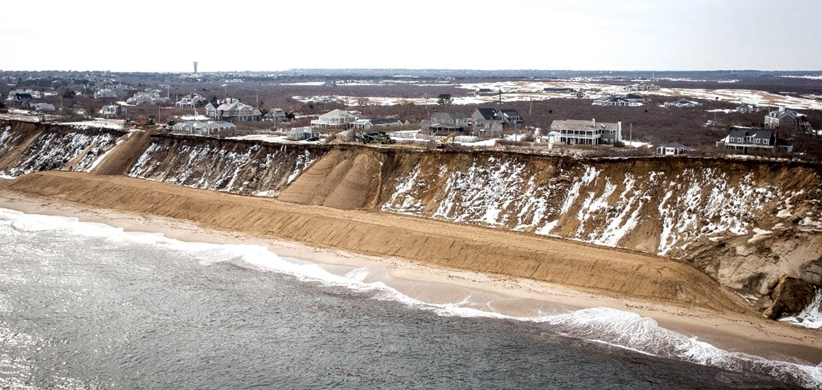
On the east coast of Nantucket, the Siasconset Beach community has experienced significant erosion of coastal bluffs, leaving historic homes, the Sankaty Head lighthouse and local roads vulnerable. Surveys of the site began in 1994 prior to the installation of an upgrade to an existing dewatering system designed to redirect water flow and reduce erosion rates (Buck and Hamilton 2017). Since that time more than 70 surveys have been completed to monitor the impact of the dewatering system upgrade (completed in December 2001) and subsequent mitigation measures. In 2013–2014, 853 feet (260 m) of geotextile tubes (Figure 2) were installed to replace the dewatering system and reduce erosion. This effort was coordinated and funded by SBPF. Due to expressed concerns from the Nantucket Conservation Commission and the general public about the transfer of erosion to the flanking areas and steepening of the beach profile in front of the geotextile tubes, a rigorous monitoring and maintenance program was established with clear failure criteria. Additionally, funds have been escrowed to remove the geotextile tubes and restore the site if the tubes were found to be ineffective or destructive to the adjacent natural environment.
Field monitoring and performance
Various offshore tropical storms and nor’easters have affected the Montauk and Nantucket areas, resulting in erosion and exposure of the GSCs and geotextile tubes. The Montauk site has been monitored since Tropical Storm Hermine (September 2016) as part of a grant from the National Science Foundation’s RAPID (Rapid Response Research) program for collecting perishable data (CMMI #1719671). Numerous post-storm surveys of the beach and dune system have been conducted and various cross-shore profiles and DEM change analyses have been developed. Cross-shore profiles for the most critical section of the project site are shown in Figure 3. The January 2017 storm has been the most severe storm to affect the site when considering peak wave characteristics and water levels. While the severity of various storms has not had a direct correlation to observed erosion due to various factors, including mean wave direction during storm events, the January 2017 storm along with Tropical Storm Hermine and the March 2018 nor’easter have provided notable datasets to support additional erosion modeling research.

Surveys were performed using RTK differential GPS, SfM photogrammetry using an UAV, and boat-mounted LIDAR and interferometric sonar. Data on peak wave characteristics and water levels were collected from the National Oceanic and Atmospheric Administration’s Data Buoy Station #44017, 23 nautical miles (43 km) SSW of Montauk Point, N.Y., and Tide Station #8510560 in Montauk. Each storm produced different levels of erosion and deposition at the site depending on the conditions. During calm periods between weather events, the beach profile recovers with the natural accretion of sand covering exposed GSCs. Since the severity of observed storms affecting the downtown Montauk Beach project site has not exceeded an estimated five-year return period, the combined waves and surge from storm events has not produced a condition where waves are directly affecting the GSC revetment as modeled in wave tank experiments conducted by Dassanayake and Oumeraci (2012).
However, based on the regular monitoring of the downtown Montauk project site and survey data provided through this research, the town completed a renourishment project in May 2018 with a total cost of $986,000 to restore the beach for the 2018 summer season (Wright 2018). This has far exceeded initial estimates of annual maintenance for the project, and in 2017, Montauk Tide Station #8510560 set a record for the number of high tide flood days per year (Sweet et al. 2018). In 2018, the number of high tide flood days per year matched the record of 11 days set in 2017, and another renourishment project was completed in May 2019 at a cost of $1 million. It is likely periodic replenishment will continue to be needed to maintain a beach profile suitable for tourism and as required by the U.S. Army Corps of Engineers operations and maintenance agreement with the Town of East Hampton, N.Y., to keep the GSCs covered. For this reason, the Montauk Beach Preservation Committee is considering the creation of an erosion control tax district (Chinese 2018).
In Nantucket, annual bluff monitoring, quarterly shoreline monitoring, annual beach invertebrate monitoring and semiannual underwater video monitoring have shown that the geotextile tubes have performed very well with minimal negative impacts on the surrounding natural environment (Hartnett 2017). During the series of nor’easters that struck in March 2018, the geotextile tubes were able to keep the toe of the bluff stabilized while other sections of the bluff without the geotextile tubes experienced erosion. While the geotextile tubes may result in the loss of sand seaward of the tubes during significant weather events, SBPF’s proactive maintenance program restores the project site to acceptable thresholds during recovery. The success of this project, particularly in terms of its well-documented performance and maintenance, has led to a follow-up proposal, approved by the Nantucket Select Board and currently under review by the Nantucket Conservation Commission, to extend the geotextile tubes an additional 2,953 feet (900 m) to reinforce additional sections of the vulnerable bluff (Sutters 2018).
Conclusion
Geosynthetic sand containers and geotextile tubes have been used for decades in emergency or temporary applications to protect homes from storms and coastal erosion. More recently, there is an appreciation that these systems, particularly when covered or used as the core of a dune, may provide protection for longer periods (e.g., 15 to 25 years). The objective of this article is to provide details of two ongoing field projects in Montauk, N.Y., and Nantucket, Mass. In Montauk, field monitoring is being used to inform town managers about annual beach replenishment requirements and performance of the GSC core during exposure. In Nantucket, demonstrated performance in protecting a portion of a coastal bluff has led to an application to extend the geotextile tubes an additional 2,953 feet (900 m) to reinforce additional sections of bluff. Collection of such performance data helps to evaluate published design approaches, develop tools for predicting performance and better inform coastal managers assessing coastal-protection alternatives to make their coastlines more resilient.
Acknowledgments
This material is based upon work supported by the National Science Foundation under Grant No. CMMI #1719671. The support of Lynn Bocamazo, P.E., D.CE, and her staff (U.S. Army Engineer District, New York), Kimberly Shaw and her staff (Town of East Hampton), Aram Terchunian and Benjamin Spratford (First Coastal Corporation), Sue Genthner (Siasconset Beach Preservation Fund) and Chris Timpson (TenCate Geosynthetics) is acknowledged and greatly appreciated.
Disclaimer
Any opinions, findings and conclusions or recommendations expressed in this material are those of the authors and do not necessarily reflect the views of the National Science Foundation.
References
Buck, M., and Hamilton, R. P. (2017). Southeast Nantucket Beach monitoring, 72nd survey report. Woods Hole Group, East Falmouth, Mass.
Chinese, V. (2018). Montauk beach erosion surfaces sooner as sandbags relent to rising sea levels. https://www.newsday.com/long-island/suffolk/montauk-erosion-1.24071066 (June 24, 2019).
Coghlan, I. R., Carley, J. T., Cox, R. J., Blacka, M., Mariani, A., Restall, S., Hornsey, W., and Sheldrick, S. (2009). “Two-dimensional physical modelling of sand filled geocontainers for coastal protection.” Proc., Australian Coasts and Ports Conf. 2009, Wellington, New Zealand.
Dassanayake, D. T., and Oumeraci, H. (2012). “Hydraulic stability of coastal structures made of geotextile sand containers (GSCs): Effect of engineering properties of GSCs.” Coastal Engineering, 33, 1–14.
Hartnett, M. (2017). “Sconset geotextile tube update, ‘Sconset Bluff,’ Nantucket.” Nantucket Coastal Conference Geotube Update. June.
Heerten, G., Jackson, A., Restall, S., and Saathoff, F. (2000). “New geotextile developments with mechanically-bonded nonwoven sand containers as soft coastal structures.” Coastal Engineering, 2342–2355.
Heilman, D. J., Perry, M. C., Thomas, R. C., and Kraus, N. C. (2008). Interaction of shore-parallel geotextile tubes and beaches along the upper Texas coast. U.S. Army Corps of Engineers, ERDC/CHL CHETN-II-51.
Hornsey, W. P., Carley, J. T., Coghlan, I. R., and Cox, R. J. (2011). “Geotextile sand container shoreline protection systems: Design and application.” Geotextiles and Geomembranes, 29, 425–439.
Lopazanski, M. (2016). Temporary erosion control structures, sandbags—History and use. North Carolina Department of Environmental Quality, Division of Coastal Management.
Recio, J. and Oumeraci, H. (2009). “Processes affecting the hydraulic stability of coastal revetments made of geotextile sand containers.” Coastal Engineering, 56, 260–284.
SBPF (2018). Geotextile tube photographs. Siasconset Beach Preservation Fund. www.sconsetbeach.org (July 2018).
Sutters, P. (2018). Select Board green-lights ConCom review of SBPF erosion-control expansion. http://www
.ack.net/news/20180725/select-board-green-lights-concom-review-of-sbpf-erosion-control-expansion (July 29, 2018).
Sweet, W. V., Marcy, D., Dusek, G., Marra, J. J., and Pendleton, M. (2018). “2017 state of U.S. high tide flooding with a 2018 outlook.” National Climate Report, May.
USACE-NAN (2014). Downtown Montauk Stabilization Project: Hurricane Sandy Limited Reevaluation Report. U.S. Army Corps of Engineers, New York District.
Wright, M. (2018). Montauk Beach Project Beat Budget Forecasts, Barely. http://www.27east.com/news/article.cfm/Montauk/558016/Montauk-Beach-Project-Beat-Budget-Forecasts-Barely (June 7, 2018).
Brian Maggi, P.E., M.ASCE, is a Ph.D. candidate at the University of Rhode Island in Kingston, a commander in the U.S. Coast Guard and an assistant professor in civil engineering at the U.S. Coast Guard Academy in New London, Conn.
Christopher D. P. Baxter is a professor in ocean/civil and environmental
engineering at the University of Rhode Island in Narragansett.
Aaron Bradshaw is an associate professor in civil and environmental engineering at the University of Rhode Island in Kingston.
Annette Grilli is an associate research professor in ocean engineering at the University of Rhode Island in Narragansett.
Naser Al Naser is a former graduate student in ocean engineering at the University of Rhode Island in Narragansett.